ESA (European Space Agency) has released sharpest high resolution world map. As per ESA, it is ten times sharper than any previous global satellite map.
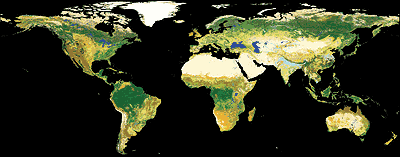
“… It is the highest resolution land cover map that has been completely validated ever released. Sixteen experts validated the map using more than 3 000 reference land cover points and showed it had an overall accuracy of 73% weighted by area for its 22 land cover classes.”
The map was generated using 19 months worth of data from Envisat’s Medium Resolution Imaging Spectrometer (MERIS) instrument working in Full Resolution Mode to provide a spatial resolution of 300 m. Data was collected between December 2004 and June 2006. Download the map, worth a view.
Download Map: JPG format – TIFF format Credits: ESA– MEDIAS France/Postel.